This past April our group decided to hike up to the summit of Mount Baldy (officially Mt. San Antonio). There are 4 ways to reach the peak. With Mt. Whitney just a few months away, we decided to challenge ourselves and take the Old Baldy Trail which is 6.4 miles long and has a gain of about 5,800 ft making it a very challenging and difficult hike.
The parking lot for this hike is located right next to the Mt. Baldy Village Church. A forest adventure pass is required.
After a quick bag check we started up Bear Canyon Rd for about .4 miles to the trailhead.
Trailhead at the end of Bear Canyon Rd
After enjoying the the sounds of the creek and sights of the cabins for .4 miles we left the paved road behind and continued on the dirt single-track trail that is Old Mt Baldy Trail. Our next destination was Bear Flat (1.8miles) here we regrouped and took a short break before continuing on for the remaining 4.6 miles.
The First 1.8 miles are the easiest…
The rest of the hike has a gain of 900 feet per mile making it very difficult. As soon as you leave Bear Flat you start to switchback up the south side of the mountain leaving you exposed to the sun , so bring a hat and pack on the sunblock! Views of Ontario Peak are all you can see from here.
Ontario Peak
After about 2 miles we hit the end of the switchbacks and continued up the ridge. This is where SoCal began to reveal itself.
getting higher and higher.. The Santa Ana Mountains are starting to reveal themselves!
If you make it here.. Just keep on going as the hardest part is now over. My favorite part of this hike(other than reaching the peak) was when we I reached the Narrows Ridge This was an Amazing experience with awesome views!
My Wife making her way up Narrows Ridge
View of Mt Baldy from Narrows Ridge
When we reached the top of the ridge my jaw dropped!
Jaw is Dropped! top of the Narrows Ridge
Up until here we were on a dirt trail which was easy to follow and easy to walk on.. This was a first for me.. hiking in the snow.. it sounds nice in ones head but the fact of the matter is this stuff was slushy and knee deep in some places.. With Baldy in our sights we had no choice but to fuel up and keep on trekking!
Once we hit the saddle between West Baldy and Baldy we had a choice to visit WB but we were just too drained, so we continued to the right and made the final push up to Baldy!
The “Sinks” is a beautiful sight to see and is located right in our own backyard! It is only accessible via private hikes through the Irvine Ranch Conservancy you can sign up for many other other activities on their website.
The Agua Chinon Trail is only 2.8 miles long but is one of the best and shortest routes to the sinks. The first mile is along the Agua Chinon wash and then the trail leaves the wash behind and starts to climb up towards the Sinks. The trail climbs several hundred feet giving you great views of Irvine to the west and the Sinks and Santa Ana mountains to the east.
The Sinks
This is one of my favorite IRC hikes and is usually available once a week. At just under 6 miles this hike offers a great workout in a short amount of time.
I came across this sad story in the Orange County Register. I can’t really imagine that this had anything to do with the conditions of the trails as Peters Canyon has always been very well maintained.
This is a wonderful 10.5 mile loop that begins at the Trabuco trailhead. To reach the trailhead you you have to travel about 5.5 miles up Trabuco Creek Rd.This parking lot is a mile or so past the Holy Jim parking lot and is a lot smaller. It only fits about 6 vehicles so arrive early.
From the trailhead you will hike through a well shaded single track trail with a couple creek crossings, an old abandoned car and a sealed up mine. You will be on this trail for 1.7 miles until you reach the junction with the west horsethief trail.
abandoned car from the mining era
Sealed up mine
Once here you can go either straight or hang a right and the continue on the Trabuco Canyon trail. They both lead you up to the Main Divide Rd. The west horsethief trail is slightly harder since it is nothing but switchbacks and is fully exposed. The Trabuco trail partially exposed for the first mile or so then changes to a well shaded trail.
We took the easier route and took the Trabuco canyon trail. This trail offers great views of Santiago peak.
Santiago Peak from Trabuco Canyon Trail
The first part of this trail it fully exposed and can be a bit difficult but gets relatively easy once in the shade. About a mile before reaching the Main Divide Rd we came across a Christmas Tree that was decorated with ornaments apparently its a tradition amongst mountain bikers to decorate a tree during the holidays. This made for a great picture spot and a quick rest break.
Christmas Tree in the CNF
Pacific Ocean in the distance
Once you reach the main divide rd you will have a great view of Lake Elsinore.
Lake Elsinore
From here take the first left you will be on this trail for 2.5. On a clear day you will have great views of the 3 biggest peaks in So.Cal
Mt. Baldy, Mt. San Gorgonio, Mt. San Jacinto
After being on this trail for 2.5 miles you reach the West Horsethief Trail.
Trail is directly behind this post
This is a 2 mile trail that consists of nothing but switchbacks. It offers great views of Trabuco Canyon. From here it’s a total of 3.7 miles back to the parking lot.
This slideshow requires JavaScript.
Happy trails, Alex G. * HIGH CLEARANCE VEHICLE RECOMMENDED * • 10.5 mile loop • Creek crossing • sealed mine • Adventure pass required • 2,300 ft elevation change
I started this hike from the San Juan Trailhead located about 2 miles down Hot Spring Canyon Rd.
This hike is 11.6 miles one way. So to avoid a 23 mile round-trip hike we parked one car at the beginning and one at the San Juan Trailhead in the bluejay campground.
(This is where you will end your hike.)
Right off the back you are faced with 17-20 switchbacks (I lost count). The elevation gain is gradual so you will barely notice it. Soon you will be rewarded with great views.
This trail is popular with mountain bikers so be extra cautious as they sometimes come speeding down in the opposite direction.
There are a few connecting trails along this hike so remember to stay to the left at every junction. Look for the mile markers to make sure that you are on the right trail.
About 6 miles in you will reach the Los Pinos Potrero this is a flat meadow with lots of Oak trees. This is a great place to take a break and relax in the shade.
The remaining 5 miles are pretty shaded and make for a great hike out.
Happy Trails
Alex G.
• 11.6 miles one way
• Elevation change- 2600 ft
• Difficulty – moderate
• Forest adventure pass
This fun and adventurous hike begins at the Palm Spring Aerial Tramway . After a 15 min ride full of stunning views, you will reach the upper station where the temperature is about 25 degrees cooler than down In the valley.
Once here you will make your way down to the main trail. After checking in at the Ranger Station you will proceed on the main trail, using the trail markers as reference. From the ranger station its 5.5 miles to the peak. Now 5.5 miles might not seem like much but hiking at high elevation is a lot tougher than hiking down in the valley. The air is thinner making it harder to breath. For me, this was my first time hiking above 9,000 feet. It took me a while to adjust to the altitude. I took breaks often to let my lungs adjust.
Most of the hike is through a beautiful forest with towering pines and amazing rock formations. Once you reach Wellmans Divide the trail changes from a dirt trail to a narrow rocky uphill battle to Wellmans Junction. At 9700 feet Wellmans Junction is a great place for a quick break and to snap a few pictures.
From here it is 2.3 miles to the peak and the most difficult part of the hike if you ask me but the views along the ridge are amazing
Once you reach the next trail marker you are almost there just .3 miles away.! First you will see the Emergency Shelter Cabin . This is a great place to stop by and visit. There is also a book for everyone to sign. Here, hikers have left emergency supplies, water and other items to assist other hikers who may be in need of help.
After exiting the shelter all that separates you from the best view of So. Cal is a quick rock scramble up to the peak. This is where you your hard work will be rewarded. the views from the peak are absolutely AMAZING! In the distance you can see Santiago Peak and San Gorgonio. It is definitely a hike that I will do over and over again.
• 10,834 ft above sea level
• Stunning Views
• 11 miles round trip
• 6 hours, 4 up 2 back + time spent at peak
• Elevation gain 2300 feet
• Difficulty- moderate / strenuous
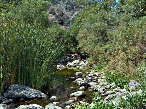
We ventured away from Orange County this weekend and headed for the cooler weather of Malibu Creek State Park. As it turned out, it ended up being quite warm in Malibu on this particular day.
This is a state park so there is a $12 fee to use the parking lot. Most people, including us, were parking on the road just outside of the park to avoid the fee.
I would definitely categorize this as a family friendly park. You have several trails to choose from and all of them have minimal elevation gain. The trails are wide and well maintained for the most part, and there are several port ‘o potties around that, according to their service logs, are cleaned pretty regularly.
The Rock Pool trail is roughly 3.5 miles roundtrip with an elevation gain of 150 feet. The payoff is a beautiful rock pool and picnic area. Being that it is pretty easy to get to, the rock pool is usually swarming with families. It was a bit disheartening to see the large amounts of trash and discarded clothing strewn about. If I were to visit the rock pool again I would definitely try to be the first person there in the morning.
The Century Lake trail is 4.5 miles roundtrip with an elevation gain of 200 feet. I wouldn’t really call this a lake. It is closer to a pond complete with lilypads. The water here is due to a dam. I witnessed a couple of young kids swimming out in the water. I wouldn’t recommend swimming here though.
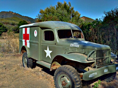
My favorite trail of the day was definitely the M*A*S*H Site trail. This trail ends up being 6.5 miles roundtrip with an elevation gain of 300 feet. When you reach the M*A*S*H Site you will find a couple of rusted out vehicles as well as a few posts with information about the television show filming that took place in the area. I was pleasantly surprised at how few people actually made it out to this area of the park.
We began our hike at 8 a.m. and there weren’t too many people around, but on our way back out it was really starting to get packed. Get there early to avoid the crowds and you’ll also have a chance to see the deer that travel the creek bed in the early morning hours.


 The Agua Chinon Trail is only 2.8 miles long but is one of the best and shortest routes to the sinks. The first mile is along the Agua Chinon wash and then the trail leaves the wash behind and starts to climb up towards the Sinks. The trail climbs several hundred feet giving you great views of Irvine to the west and the Sinks and Santa Ana mountains to the east.