• Easy Hikes
  • Moderate Hikes
  • Strenuous Hikes
  • Waterfalls
  • Outdoors
  • Distance hikes
  • Peaks
  • Caves
  • News
  • The 10 Essentials
  • Directions to our Favorite Trails

Your Favorite Hiker

~ Exploring SoCal and beyond!

Your Favorite Hiker

Tag Archives: mount baldy

Mt. Baldy- Ski Hut-Devils Backbone Loop

22 Tuesday Oct 2013

Posted by Alex G in Distance hikes, Outdoors, Peaks, Strenuous Hikes

≈ Leave a comment

Tags

Hiking, mount baldy, mountain, my baldy, nature, outdoors, peak

image

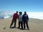
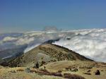
Mt Baldy is the highest mountain in the Los Angeles area and  is a very popular hike amongst the hiking community. I’ve had the pleasure of summiting this mountain 6 times and the view is just as breathtaking as the first time.

image

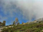
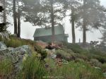
Ski Hut from the trail

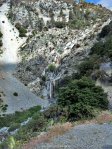
The Ski Hut Trail begins about .6 miles up Falls Rd passing San Antonio Falls. There used to be a sign marking the obscure trail but that has since be removed. So keep by our eyes open as this trail is easy to miss. It is on the left hand side.

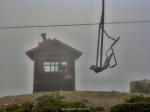
The Ski Hut marks the halfway point to the summit. This is a great place to stop have a snack and if you’re lucky you might even spot some wildlife.

image

Deer grazing just below the Ski Hut

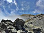
From here you will cross the Baldy Bowl, do a little boulder scrambling and then back into the pine forest to continue the ascend to the summit. 

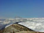
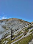
Once at the summit if you look in a Southeastern direction you will the the Devils Backbone Trail. Views from this trail are amazing!

image

Devils Backbone viewed fromnthe Summit

image

image

Take this trail down to the Baldy Notch (Ski lifts) from there you can either take the ski lifts down (if they’re running) or take the road down which is directly behind the restaurant. The road will take you back down and pass up the waterfall and leave you back at your car.

Click here for directions to the parking lot

***BE SURE TO USE EXTREME CAUTION WHEN HIKING ON THE DEVILS BACKBONE TRAIL. I DO NOT RECOMMEND HIKING THIS TRAIL AFTER SNOW FALL. PEOPLE HAVE DIED ON THIS TRAIL BEFORE ***

• 11.3 MILE LOOP
• HIKING POLES RECOMMENDED
• AMAZING VIEWS
• 3‚900 FT OF GAIN
• 7-9 HRS TO COMPLETE
• ADVENTURE PASS IS REQUIRED

Like this:

Like Loading...

MOUNT BALDY (via the Ski Hut Trail)

27 Wednesday Jun 2012

Posted by Alex G in Distance hikes, Outdoors, Peaks, Strenuous Hikes, Waterfalls

≈ Leave a comment

Tags

distance, Hiking, manker flats, mount, mount baldy, mount whitney training hike, mountain, outdoors, peak, san antonio, San Gabriel Mountains, ski hut, strenuous, trail, waterfall

SAN ANTONIO FALLS

With my Mount Whitney hike fast approaching I decided to get serious about my training. Already have done Mt Baldy (via Old Baldy Trail) which was a butt kicker I decided to try out the shorter but equally as hard route to the summit. At 4.2 miles and with a gain of 4,000 ft. This is the shortest and quickest way to the top.

The trail begins at the intersection of Mt. Baldy Rd and Falls Rd. there is plenty of parking and a Forest Adventure pass is required. The first mile of this hike is on a road. At .5 miles you will reach San Antonio Falls. On this particular May day the falls were less impressive than I had imagined.. but hey it was a pretty dry winter.

After making a sharp right turn past the falls the roads turns to the left and at about .8 miles  there will be an unmarked steep  single track trail to your left. This us the Ski Hut Trail. If you aren’t paying attention, you will miss it. We almost did if it wasn’t for a fellow hiker.

The next 3.5 miles are unbelievable, amazing and breathtaking! (Especially the breathtaking part) As soon as I started I immediately knew it was going to be a tough hike. I caught myself stopping more frequently than ever before.

It felt like the torture would never end!

What seemed to be an eternity was really only like an hour and a half of hiking… Finally through the cover of the clouds I got a glimpse of the ski hut.

FIRST VIEW OF THE SKI HUT ON A CLOUDY MORNING

Finally! The halfway point… great place to rest, re-energize, take a bathroom break and carb up before continuing on the final half of the hike.

ONE OF THE MANY PLACES TO REST AT THE SKI HUT

After a nice 30 minute rest. We geared up and continued on our mission! Just 2 more miles! Sounds easy but there is still one last hard section before the final push!

My buddy Neal

Winding our way up the mountain through a series of boulders and pines. There was no snow left on the mountain but there was a lot of ice covered trees. Which made for great photos.

After the last hard part the trail becomes relatively easy and the blue skies begin to open up indicating that the top of the ridge is getting closer. This usually gives me that extra motivation to keep on trekking!

NEARING THE TOP

YOURS TRULY, ON THE SUMMIT

This is probably the best 4.5 mile hike around. It offers a bit of everything.. A waterfall, a steep incline, beautiful scenery and an amazing view! Definitely a must do for all serious hikers!

  • 4.5 miles to the top
  • Difficulty – strenuous
  • 4,000 ft elevation gain
  • beautiful scenery
  • waterfall
  • 10,064
  • highest point in LA

RETURN OPTIONS:

  1. Return the way you came (9 miles)
  2. go down the devils backbone which will take you back to the trailhead with an added 2 miles on the return (apprx. 11 miles  r.t)
  3. go down Old Baldy Trail (6.4 miles) requires a car shuttle (11 miles r.t)
GETTING CLOSER TO THE SUMMIT!
ICY TREES ON THE FINAL PUSH
PHIL MYSELF AND NEAL

LOOKING TOWARDS THE DEVILS BACKBONE
HIKING ABOVE THE CLOUDS
TWISTED TREE

SKI HUT OUTHOUSE
VIEW FROM THE SUMMIT
YOURS TRULY, ON THE SUMMIT

ALMOST TO THE TOP
SKI LIFT

DEVILS BACKBONE TRAIL
ABOVE THE CLOUD LINE 10,054 FT
A VIEW FROM THE SUMMIT

ICE COVERED TREE
NO SNOW, BUT LOTS OF ICE
SKI HUT

FIRST VIEW OF THE SKI HUT ON A CLOUDY MORNING
ONE OF THE MANY PLACES TO REST AT THE SKI HUT


ON THE SUMMIT
LOOKING BACK UP AT BALDY, VIA DEVILS BACKBONE TRAIL
LOOKING BACK UP AT BALDY

ICY PINES
SAN ANTONIO FALLS

NEARING THE TOP

Like this:

Like Loading...

MOUNT BALDY (via Old Baldy Trail)

10 Thursday May 2012

Posted by Alex G in Distance hikes, Outdoors, Peaks, Strenuous Hikes

≈ 8 Comments

Tags

california, climbing, hike, Hiking, hiking group, los angeles, mount baldy, mountain, mountain range, Mt. Baldy, peak, san antonio peak, San Gabriels, snow, summit, trail, Trails, views

Plaque on the top of Baldy

This past April our group decided to hike up to the summit of Mount Baldy (officially Mt. San Antonio).  There are 4 ways to reach the peak. With Mt. Whitney just a few months away, we decided to challenge ourselves and take the Old Baldy Trail which is 6.4 miles long and has a gain of about 5,800 ft making it a very challenging and difficult hike.

The parking lot for this hike is located right next to the Mt. Baldy Village Church. A forest adventure pass is required.

After a quick bag check we started up Bear Canyon Rd for about .4 miles to the trailhead.

Trailhead at the end of Bear Canyon Rd

After enjoying the the sounds of the creek and sights of the cabins for .4 miles we left the paved road behind and continued on the dirt single-track trail that is Old Mt Baldy Trail. Our next destination was Bear Flat (1.8miles) here we regrouped and took a short break before continuing on for the remaining 4.6 miles.

The First 1.8 miles are the easiest…

The rest of the hike has a gain of 900 feet per mile making it very difficult.  As soon as you leave Bear Flat you start to switchback up the south side of the mountain leaving you exposed to the sun , so bring a hat and pack on the sunblock! Views of Ontario Peak are all you can see from here.

Ontario Peak

After about 2 miles we hit the end of the switchbacks and continued up the ridge. This is where SoCal began to reveal itself.

getting higher and higher.. The Santa Ana Mountains are starting to reveal themselves!

If you make it here.. Just keep on going as the hardest part is now over. My favorite part of this hike(other than reaching the peak) was when we I reached the Narrows Ridge This was an Amazing experience with awesome views!

My Wife making her way up Narrows Ridge

View of Mt Baldy from Narrows Ridge

When we reached the top of the ridge my jaw dropped!

Jaw is Dropped! top of the Narrows Ridge

Up until here we were on a dirt trail which was easy to follow and easy to walk on.. This was a first for me.. hiking in the snow.. it sounds nice in ones head but the fact of the matter is this stuff was slushy and knee deep in some places.. With Baldy in our sights we had no choice but to fuel up and keep on trekking!

Once we hit the saddle between West Baldy and Baldy we had a choice to visit WB but we were just too drained, so we continued to the right and made the final push up to Baldy!

WE MADE IT!!!!

My krew and I on the highest peak in LA

Happy Trails,
Alex G.

This slideshow requires JavaScript.

  • 12.8 round-trip
  • 6.4 miles to the top
  • 900 ft of gain per mile
  • 5,800 ft of gain
  • 10,834 ft peak
  • Tallest peak in LA
  • 3rd tallest peak in So Cal
  • adventure pass required
  • Difficulty– Very Strenuous
  • start early to beat the heat 6 or 7am
  • total hike time 7-11 hours depending on pace

Like this:

Like Loading...

Blog Stats

  • 118,832 views

Top Posts & Pages

  • AGUA CHINON TO THE SINKS
  • Ladder Canyon (Mecca Hills, CA)
  • BLACK MOUNTAIN -HENDERSON,NV
  • The Wally Waldron Tree
  • Mt. Baldy- Ski Hut-Devils Backbone Loop
  • BLACK STAR CANYON INDIAN VILLAGE

Enter your email address to follow this blog and receive notifications of new posts by email.

Join 401 other subscribers

Advertisement

Archive

Blog at WordPress.com.

Privacy & Cookies: This site uses cookies. By continuing to use this website, you agree to their use.
To find out more, including how to control cookies, see here: Cookie Policy
  • Follow Following
    • Your Favorite Hiker
    • Join 61 other followers
    • Already have a WordPress.com account? Log in now.
    • Your Favorite Hiker
    • Customize
    • Follow Following
    • Sign up
    • Log in
    • Report this content
    • View site in Reader
    • Manage subscriptions
    • Collapse this bar
 

Loading Comments...
 

    %d bloggers like this: