• Easy Hikes
  • Moderate Hikes
  • Strenuous Hikes
  • Waterfalls
  • Outdoors
  • Distance hikes
  • Peaks
  • Caves
  • News
  • The 10 Essentials
  • Directions to our Favorite Trails

Your Favorite Hiker

~ Exploring SoCal and beyond!

Your Favorite Hiker

Tag Archives: orange county

BLACK STAR CANYON INDIAN VILLAGE

26 Sunday Apr 2015

Posted by Alex G in Distance hikes, Outdoors, Strenuous Hikes

≈ 4 Comments

Tags

black star, Black Star Canyon, california, cleveland national forest, Hiking, indians, native people, orange county, santa ana mountains, tongva

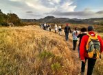
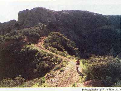
Black Star Canyon Indian village is located a little more than 5 miles from the trailhead on Black Star Canyon Rd. The trail starts off moderate for the first 2 miles as you make your way up the canyon. The last 3+ miles up to the Indian site are the strenuous  part. The trail climbs up the canyon walls as it takes you into the Cleveland  National Forest. The site is easy to miss since it’s not marked. Just look for the grove of Oak Trees a little after the 5 mile mark. It is on the right hand side.

The canyon is full of history! Including the story about the Indian massacre.  You can read about is on the Wikipedia page.

image

image

image

image

image

Click for Directions to trailhead

● Trail difficulty – strenuous
● 10.5 miles roundtrip
● Trail type – out and back
●  mostly exposed – bring sun protection
● Bring minimum  2 liters of water
● California  historic  site 217

Like this:

Like Loading...

LOS PINOS PEAK VIA TRABUCO CANYON

19 Friday Dec 2014

Posted by Alex G in Distance hikes, Outdoors, Peaks, Strenuous Hikes

≈ Leave a comment

Tags

california, cleveland national forest, Hiking, Holy jim, Main Divide road, nature, orange county, outdoors, santa ana mountains, Trabuco canyon

This is a 13 mile hike that starts in beautiful Trabuco Canyon. The trailhead for this hike is located at the end of Trabuco Creek Rd. This is a bumpy ride on an  unmaintained dirt road. So a 4×4 or a high clearance vehicle is recommended.

image

The first 2 miles on the West Horsethief Trail are mostly shaded and follow the creek.

image

View of Trabuco Canyon

After the first 2 miles you start to climb up the walls of Trabuco Canyon and the views begin to open up. This steep section is the toughest part of the hike. After 2 miles you reach the Main Divide Rd.

image

The Main Divide  Rd. offers some great views into Riverside County. Lake Elsinore is pictured above also visible from the road are San Jacinto and the San Bernardino Mountains. 

image

Los Pinos Ridge Trail

After 3 miles on the Rd you reach the Los Pinos Trail. This ridge line is one of my favorites in the range. The views from the ridge are amazing!

image

View from Los Pinos Peak

Once on the peak, enjoy the marvelous views an retrace your steps.  Go back to the main divide/los pinos junction and make a left to take the Trabuco Canyon trail. 

This shady downhill trail is my favorite!  It’s a bit rocky but the views are so worth it!

image

Trabuco Canyon Trail

image

This Trai will take you back to West Horsethief trail. Then return the way you came. This lollipop loop is one of the best in So Cal!

Trail route:
West Horsethief to Main Divide, Main Divide to Los Pinos Trail, Los Pinos  back down to Main Divide/Trabuco Canyon/ Los Pinos trail Junction,  Take Trabuco Canyon trail back to West Horsethief and back to parking lot.

● 13 mile Lollipop Loop
● 4th highest peak in the range.
● Beautiful views
● Dog friendly trail
● approx 2,500 ft of gain
● High clearance vehicle recommended

CLICK BELOW FOR GOOGLE MAPS LINK TO PARKING AREA
West Horsethief/Trabuco Canyon Trailhead

Follow me on Instagram for more outdoor photos and info on hikes.

Like this:

Like Loading...

Mile Mile and a Half Movie Screening

27 Tuesday Aug 2013

Posted by Alex G in Outdoors

≈ 1 Comment

Tags

backpacking, california, Hiking, JMT, John Muir trail, mountains, movie, nature, orange county, outdoors

image

http://www.tugg.com/events/5189

Mile…Mile & A Half in Orange, CA on Wednesday, September 25, 7:00pm

Trying to get enough people  signed up to get this awesome movie brought to OC for us to enjoy.

Please spread the word!

Like this:

Like Loading...

Gallery

Baker Canyon Night Hike with Google Glass

24 Monday Jun 2013

Posted by octrailhikers in Moderate Hikes

≈ Leave a comment

Tags

Android, Baker Canyon, blackstar canyon, Google Glass, Hiking, orange county, santiago canyon, ThroughGlass

This gallery contains 5 photos.

The “Super Moon” hike didn’t pan out the way I had hoped thanks to the clouds, but the hike was …

Continue reading →

Deer Trail – Santiago Oaks Regional Park

04 Thursday Apr 2013

Posted by Alex G in Outdoors, Uncategorized

≈ Leave a comment

Tags

Hiking, nature, OC Parks, orange county, outdoors, Santiago oaks

image

Deer Trail

Santiago Oaks is one of my favorite parks to visit for a quick day hike. The nearly 2,000 acre park is on the border of wilderness and residental areas making it easly accessible. There are many trails within the park one of my favorite is the Deer Trail. At under a mile this small detour is worth the visit.

image

The trail can be access via Burnham Ridge or as you come down Robbers Peak. This is some what of a spur trail but there is also another trail that leads up and away from the canyon but that will take you to Weir Canyon so avoid that trail.

image

Meadow at the bottom of Deer Trail

The trail quickly descends the backside of Santiago Oaks and parallels this nice meadow and Oak grove. Make sure to pay this beautiful trail a visit on your next visit to Santiago Oaks.

Click here for directions

Like this:

Like Loading...

Gallery

The Coastal Redwoods of Orange County

31 Tuesday Jan 2012

Posted by octrailhikers in Easy Hikes, Outdoors

≈ 1 Comment

Tags

Carbon Canyon, Coastal Redwoods, Hiking, orange county, Parks, Redwoods, Regional Park, Trails

This gallery contains 4 photos.

Carbon Canyon Regional Park

Bicyclist dies after rescue from Peters Canyon

31 Tuesday Jan 2012

Posted by octrailhikers in News

≈ Leave a comment

Tags

heart attack, Hiking, Mountain biking, orange county, park, peters canyon, Trails

image

I came across this sad story in the Orange County Register. I can’t really imagine that this had anything to do with the conditions of the trails as Peters Canyon has always been very well maintained.

http://www.ocregister.com/news/victim-338016-firefighters-rescued.html

Like this:

Like Loading...

Petition to Save the Santiago Truck Trail

18 Sunday Sep 2011

Posted by octrailhikers in News, Outdoors

≈ Leave a comment

Tags

county land, Hiking, luge, Mountain biking, OC Trail Hikers, orange county, peak, petition, santiago canyon, single track

image

The Santiago Truck Trail is at risk of being closed to the public. The County is contemplating purchasing the land from it’s current owners at a cost of $2.3 million. Please take the time to sign the petition and help preserve our open spaces. The Santiago Truck Trail leads up to The Luge (video), a popular single track mountain bike trail.

http://www.ipetitions.com/petition/savestt/

Posted from WordPress for Android

Like this:

Like Loading...

Blog Stats

  • 118,832 views

Top Posts & Pages

  • AGUA CHINON TO THE SINKS
  • Ladder Canyon (Mecca Hills, CA)
  • BLACK MOUNTAIN -HENDERSON,NV
  • The Wally Waldron Tree
  • Mt. Baldy- Ski Hut-Devils Backbone Loop
  • BLACK STAR CANYON INDIAN VILLAGE

Enter your email address to follow this blog and receive notifications of new posts by email.

Join 401 other subscribers

Advertisement

Archive

Blog at WordPress.com.

Privacy & Cookies: This site uses cookies. By continuing to use this website, you agree to their use.
To find out more, including how to control cookies, see here: Cookie Policy
  • Follow Following
    • Your Favorite Hiker
    • Join 61 other followers
    • Already have a WordPress.com account? Log in now.
    • Your Favorite Hiker
    • Customize
    • Follow Following
    • Sign up
    • Log in
    • Report this content
    • View site in Reader
    • Manage subscriptions
    • Collapse this bar
%d bloggers like this: