
Tags
distance, Hiking, manker flats, mount, mount baldy, mount whitney training hike, mountain, outdoors, peak, san antonio, San Gabriel Mountains, ski hut, strenuous, trail, waterfall

SAN ANTONIO FALLS
With my Mount Whitney hike fast approaching I decided to get serious about my training. Already have done Mt Baldy (via Old Baldy Trail) which was a butt kicker I decided to try out the shorter but equally as hard route to the summit. At 4.2 miles and with a gain of 4,000 ft. This is the shortest and quickest way to the top.
The trail begins at the intersection of Mt. Baldy Rd and Falls Rd. there is plenty of parking and a Forest Adventure pass is required. The first mile of this hike is on a road. At .5 miles you will reach San Antonio Falls. On this particular May day the falls were less impressive than I had imagined.. but hey it was a pretty dry winter.
After making a sharp right turn past the falls the roads turns to the left and at about .8 miles there will be an unmarked steep single track trail to your left. This us the Ski Hut Trail. If you aren’t paying attention, you will miss it. We almost did if it wasn’t for a fellow hiker.
The next 3.5 miles are unbelievable, amazing and breathtaking! (Especially the breathtaking part) As soon as I started I immediately knew it was going to be a tough hike. I caught myself stopping more frequently than ever before.
It felt like the torture would never end!
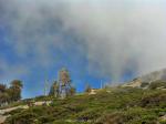
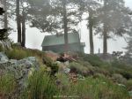
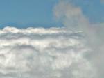
What seemed to be an eternity was really only like an hour and a half of hiking… Finally through the cover of the clouds I got a glimpse of the ski hut.

FIRST VIEW OF THE SKI HUT ON A CLOUDY MORNING
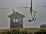
Finally! The halfway point… great place to rest, re-energize, take a bathroom break and carb up before continuing on the final half of the hike.

ONE OF THE MANY PLACES TO REST AT THE SKI HUT
After a nice 30 minute rest. We geared up and continued on our mission! Just 2 more miles! Sounds easy but there is still one last hard section before the final push!

My buddy Neal
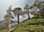
Winding our way up the mountain through a series of boulders and pines. There was no snow left on the mountain but there was a lot of ice covered trees. Which made for great photos.
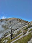
After the last hard part the trail becomes relatively easy and the blue skies begin to open up indicating that the top of the ridge is getting closer. This usually gives me that extra motivation to keep on trekking!

NEARING THE TOP

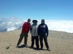
YOURS TRULY, ON THE SUMMIT
This is probably the best 4.5 mile hike around. It offers a bit of everything.. A waterfall, a steep incline, beautiful scenery and an amazing view! Definitely a must do for all serious hikers!
- 4.5 miles to the top
- Difficulty – strenuous
- 4,000 ft elevation gain
- beautiful scenery
- waterfall
- 10,064
- highest point in LA
RETURN OPTIONS:
- Return the way you came (9 miles)
- go down the devils backbone which will take you back to the trailhead with an added 2 miles on the return (apprx. 11 miles r.t)
- go down Old Baldy Trail (6.4 miles) requires a car shuttle (11 miles r.t)
-

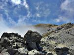
- GETTING CLOSER TO THE SUMMIT!
-

- ICY TREES ON THE FINAL PUSH
-
- PHIL MYSELF AND NEAL
-

- LOOKING TOWARDS THE DEVILS BACKBONE
-

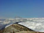
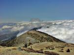
- HIKING ABOVE THE CLOUDS
-

- TWISTED TREE
-

- SKI HUT OUTHOUSE
-

- VIEW FROM THE SUMMIT
-

- YOURS TRULY, ON THE SUMMIT
-
- ALMOST TO THE TOP
-
- SKI LIFT

-
- DEVILS BACKBONE TRAIL
-

- ABOVE THE CLOUD LINE 10,054 FT
-
- A VIEW FROM THE SUMMIT
-

- ICE COVERED TREE
-

- NO SNOW, BUT LOTS OF ICE
-

- SKI HUT

-
- FIRST VIEW OF THE SKI HUT ON A CLOUDY MORNING
-

- ONE OF THE MANY PLACES TO REST AT THE SKI HUT


-

- ON THE SUMMIT
-
- LOOKING BACK UP AT BALDY, VIA DEVILS BACKBONE TRAIL
-
- LOOKING BACK UP AT BALDY
-

- ICY PINES
-
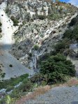
- SAN ANTONIO FALLS

-

- NEARING THE TOP
