• Easy Hikes
  • Moderate Hikes
  • Strenuous Hikes
  • Waterfalls
  • Outdoors
  • Distance hikes
  • Peaks
  • Caves
  • News
  • The 10 Essentials
  • Directions to our Favorite Trails

Your Favorite Hiker

~ Exploring SoCal and beyond!

Your Favorite Hiker

Tag Archives: waterfall

EATON CANYON WATERFALL

21 Wednesday Sep 2011

Posted by Alex G in Easy Hikes, Waterfalls

≈ 1 Comment

Tags

Eaton Canyon, Hiking, waterfall

Eaton Canyon is one of those places that is tucked away right beneath our noses. It is literally a few blocks from the freeway. Making it a great place for a quick day hike.

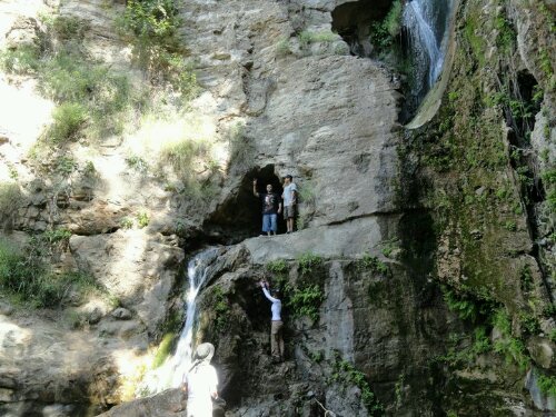
Eaton Canyon Waterfall is located in Pasadena, Ca and is a beautiful sight! Much like other waterfalls located in the San Gabriel Mountains. The waterfall itself is 50 ft with a large pool at its base. It is at the end of a 1.5 mile trail that begins at the parking lot of the Eaton Canyon Nature Center. Parking here is free of charge.

With a total Elevation gain of about 400 ft in 1.5 miles this hike is good for people of all ages. The first mile is on a dirt trail until you reach the Mt Wilson Toll Bridge. As u pass under the bridge you will soon notice the creek on the left hand side, there are a couple small pools here, this a great spot to take some pictures and enjoy the scenery.

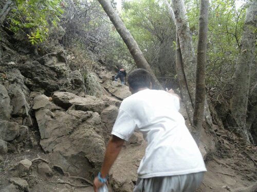
The remainder .5 miles is in a narrow part of the canyon and consists of creek crossings and some rock scrambling so be careful on this last part.

There are a few side trails that branch off from the main trail. STAY ON THE MAIN TRAIL!!! Eaton Canyon has been the subject of multiple deaths this year News Link. the easiest way to get lost or seriously injured is by venturing off the main trail.

This is a popular hike so it does get crowded. Get there early if possible.

• 50 ft Waterfall
• 3 mile round trip
• Difficulty- Easy
• Free Parking
• 400 ft elevation gain
Click here for directions

Happy Trails,
Alex G

Like this:

Like Loading...

Missing Hiker in the Valley of the Falls

09 Friday Sep 2011

Posted by octrailhikers in News

≈ Leave a comment

Tags

Forest Falls, Hiking, waterfall

image

Rescue crews search for missing hiker Bryan Gutierrez near San Gorgonio Peak in the Valley of the Falls http://bit.ly/oZZJbn

Posted from WordPress for Android

Like this:

Like Loading...

Girl, 11, dies after being hit by falling rock in Forest Falls

06 Tuesday Sep 2011

Posted by Alex G in News

≈ Leave a comment

Tags

Big Falls, Forest Falls, Rockslide, waterfall

This is a sad reminder to always use caution when out in the wilderness.

Girl, 11, dies after being hit by falling rock in Forest Falls | abc7.com.

Like this:

Like Loading...

MARY JANE FALLS

26 Friday Aug 2011

Posted by Alex G in Cave, Outdoors, Strenuous Hikes, Waterfalls

≈ 3 Comments

Tags

cave, forest, Hiking, Las Vegas, mt. Charleston, Nevada, spring mountains, waterfall

Mary Jane Falls… WOW!
This is probably the best hike I’ve been on so far for one reason and one reason only, the location!

Located 40 minutes north of the Las Vegas Strip there is a hidden paradise. A place that is overshadowed by the towering hotels and casinos. This amazing oasis is located in the Spring Mountains of southern Nevada.

This isolated adventure begins way before you reach the Mary Jane Falls Trailhead. As you leave the city in your rear view you will soon be driving down a one lane highway with amazing rockscape on either side. The scenery changes drastically in a matter of seconds. You will find yourself driving along a pine and campground filled highway (reminded me of the San Bernardino national Forest)

Now this is where the fun begins. Once you have parked you will notice the trailhead sign and the trail directly behind it. The first 1/3 mile is at a slight incline along a rocky trail. you will soon reach a sign that reads “trail” at the base of the switchbacks. (At this point I took some time to let my lungs adjust to the elevation before continuing) on the trail up the switchbacks you will see towering Ponderosa Pines, White fur and Aspen trees in the canyon below.

As you reach the top of the switchbacks you have an amazing view of Kyle Canyon and the canyon walls and you suddenly realize that you are 9,000+ ft above sea level. Such and amazing feeling.

When you reach the falls you will be in awe at the height of these natural wonders. The view is amazing! There are 2 caves, 3 waterfalls and a view of Big Falls, which is across the canyon.

I can’t wait till my next trip to Vegas. This is a must do hike. It is great for kids, dogs and adults.

The best part of this hike is that the temperature is 20-25 degrees cooler than in the LV valley. Excellent for hiking in the summer.

Happy Trails,
Alex G

•Waterfall
•1000 ft elevation gain
•Cave
•3 miles round trip
•free parking

Like this:

Like Loading...

Man dies in fall over Yosemite’s Half Dome

25 Thursday Aug 2011

Posted by Alex G in News

≈ Leave a comment

Tags

halfdome, Hiking, waterfall, Yosemite

Man dies in fall over Yosemite’s Half Dome | abc7.com.

Like this:

Like Loading...

Escondido Canyon Waterfall

24 Wednesday Aug 2011

Posted by octrailhikers in Easy Hikes, Outdoors, Waterfalls

≈ Leave a comment

Tags

bats, boulders, caves, climbing, Creek, escondido canyon, Hiking, Malibu, OC Trail Hikers, ropes, santa monica mountains, waterfall

image

image

image

image


     Escondido Falls is a great trail to hike anytime of year. This trail is located in the Santa Monica Mountains of Malbu. The proximity to the coast provides relief from the heat of the SoCal Summer. The temperature here usually lingers in the mid to upper 60’s. The only drawback to hiking this close to the exclusive sands of Baywatch Beach would be the very limited parking. You will definitely want to arrive early.The tiny parking lot is located at Winding Way and PCH.There are no parking fees.
     The trailhead is about 1/2 a mile north on Winding Way from the parking lot. Winding Way is basically a private road leading to some pretty swanky homes. The entire hike ends up being about 4.2 miles roundtrip. I would say that it is a pretty family friendly trail as long as your children are at least 6 years of age. Poison oak is abundant here. You will want to keep everyone on the trail. There is some bouldering involved and there is a pretty steep portion of trail where you may choose to use a rope that someone has setup to aid you in your climb.
    There are a couple of small waterfalls along the first portion of the trail, but it is the last waterfall that you will really want to see. The last waterfall is a multi-tiered beauty with a total height of roughly 150 feet. It isn’t your typical California waterfall. This one is covered in moss and grass and is definitely this most tropical looking waterfall that we have experienced (YouTube Link).

-FPMiv

Like this:

Like Loading...

HARDING CANYON WATERFALL

20 Saturday Aug 2011

Posted by Alex G in Outdoors, Strenuous Hikes, Waterfalls

≈ 8 Comments

Tags

Creek, pools, waterfall

In March of 2011 our sense of adventure led us to Modjeska Canyon, Ca for an attempt to reach Harding Canyon Waterfall.

We geared up and headed towards the Santa Ana Mountains to reach the trailhead before sunrise. Parking for Harding Canyon Falls is located at the Tucker Wildlife Sanctuary Parking here is free but limited, so arrive early for a spot.

The trail begins to the right of the sanctuary on Harding Truck Trail. After a .25 mile walk at a slight incline you reach a fork in the road. From here go left and you will soon reach the creek bed. Head to your right until you reach the creek. Now here is where the fun part begins.

By no means is this an easy hike so be prepared for a long and wet hike.

Head up creek for 3 1/2 hours… Yes that’s right 3 1/2 hours. On this adventure you will hike along the creek, in the creek and across the creek. Staying dry is not an option. You will see some of the best creek pools around! (Great for the summer months) The trail is very shaded and sprawling with plant life including the infamous Poison Oak, so be aware of your surroundings. Newts lizards frogs and snakes are also common along the trail so keep an eye out.

After several creek crossings the canyon begins to narrow and the boulders begin to appear. Continue on up creek for the waterfall is just around the way. (that’s what I kept telling myself)

After a long, challenging, wet hike you should now be embracing the sight of Harding Canyons hidden beauty. A beautiful 40 ft waterfall with a waist deep pool at its base.

Although very difficult it is still very doable. As always be prepared and use common sense.

Click here for directions

•waterfall
•creek
•pools
•8 miles r/t
•3 1/2 hrs one way
•free but limited parking

Like this:

Like Loading...

FISH CANYON WATERFALL

19 Friday Aug 2011

Posted by Alex G in Moderate Hikes, Outdoors, Waterfalls

≈ Leave a comment

Tags

Creek, fish canyon, Hiking, waterfall

Darlin' Donna waterall

Fish Canyon Falls is one of those sights that leaves you in awe. Truly one the best waterfalls that the San Gabriel Mountains has to offer. The adventure begins juat beyond the Parking Lot From here you begin your 2.2 mile adventure. Along the trail you will see ruins of old cabins,  wild berries, and posted signs with history of the canyon. With only 2 creek crossings this is one of the more easier and drier waterfall hikes around.

Once you’ve reached the waterfall getting to it can be a bit tough… between you and pool at the base lies a small but steep slope. With careful navigation make your way down and grab a seat.

This place gets bit crowded because on the weekends, so start your hike early for preferred seating. Trailhead opens at 7am. This is a well shaded trail along Fish Creek which is perfect for the hot months.

On your way back from the falls take the time to visit a hidden waterfall. I saw so many people walk right pass the trail and didn’t even realize it.  The trail is easy to find if you know what you are looking for. On your way back  look for the natural staircase that is formed from the roots of a tree. Shortly after passing that you will come across a bend in the trail with what appears to be a runoff  to your right.. follow that trail for 1 minute and there you will see Darlin’ Donna Waterfall, Fish Canyons Hidden beauty.

Enjoy !

Alex G

For directions click here

  • waterfall
  • creek
  • 4 miles r/t
  • free parking

Like this:

Like Loading...

Blackstar Canyon Waterfall

18 Thursday Aug 2011

Posted by octrailhikers in Cave, Outdoors, Strenuous Hikes, Waterfalls

≈ 1 Comment

Tags

blackstar, canyon, cave, county, Creek, Hiking, irvine, oc, orange, salamander, waterfall

image

image

image

image

     If you have grown up in OC, chances are that you have heard the stories surrounding Blackstar Canyon. These stories range from hauntings to cult sacrifices to murderous  squatters. While I’m not willing to confirm or deny the validity of any of these tales, I can tell you that there is indeed a pretty spectacular waterfall hidden here.
     Most hikers that venture into Blackstar Canyon never make it quite far enough into the canyon to find the waterfall trail. Those that do make it in are likely to pass right by the shrub covered creek entrance. From the parking area the creek entrance is 2.5 miles along a relatively flat fire road, and you can find it as long as you know what to look for. You will easily spot a couple of large concrete tubes at the point where the trail begins to climb. Directly to the right of these cylinders you will spot a small clearance in the brush that is bordering the trail. This is the entrance down into the creek.
     The creek  portion of the hike provides some pretty challenging boulder climbing which is obviously most difficult in the winter and spring months due to the rain. The trek through the creek is an additional 2.5 miles, but plan on it feeling more like 4 miles when you factor in all of the climbing. Be sure to pack plenty of water and some light snacks. A first aid kit would also be a wise choice. This trail is covered in poison oak and I have witnessed a pretty nasty cut resulting in 14 stitches as well as someone taking a tumble from the cave that is alongside the waterfall.
     This is one of the more challenging trails that I have experienced in OC, but I would say that the payoff is well worth it. The Blackstar Canyon Waterfall is a spectacular site especially in the rainy season, and it is still very impressive in the dry season when the water is but a trickle. When you first lay eyes upon it I’m sure you’ll be just as surprised as I was that such a thing exists right in our own backyard.

-FPMiv
    

Posted from WordPress for Android

Like this:

Like Loading...

WATERFALLS OF TRABUCO CANYON

17 Wednesday Aug 2011

Posted by Alex G in Moderate Hikes, Outdoors, Waterfalls

≈ 6 Comments

Tags

Creek, Hiking, trabuco, waterfall

Holy Jim Waterfall

Holy Jim Waterfall

Falls Canyon Waterfall

Falls Canyon Waterfall

Looking for a quick getaway? Have I got the spot for you. Located just a few minutes from both the city of Orange and Rancho Santa Margarita is a place called Trabuco Canyon . This natural wonderland is home to two of my favorite local waterfalls.

The first of the two is Holy Jim Waterfall which is around 4.25 miles round trip from the parking lot and back. (If you continue left on Holy Jim Rd, which is the road that’s directly behind the information board, you can drive about 3/4 of a mile further in and park at the Trailhead) This a short but rewarding hike. Lined with Oak, Sycamore, Maple and Fig Trees, this trail is very shady, great for hiking in the summer months. The trail begins after a slow and bumpy 4.5 mile drive up Trabuco Creek Rd which brings you to the Holy Jim Parking lot. From here go up the steps that lead to the trail and continue left. (Between here an the waterfall you will cross the creek about 6 times) You will soon find yourself walking along a trail lined with rustic cabins. When u reach the Holy Jim Trailhead follow this trail until you reach the Main Divide/ Holy Jim junction, continue right for a short distance until you reach the waterfall. Once here you can enjoy the sights and sounds of the 20ft wonder hidden in the canyon.

The 2nd and more impressive waterfall measuring at about 40ft is Falls Canyon Waterfall. This trail is a bit tricky to find because it is tucked away in a small canyon on the opposite side of the creek. To reach this trail one must start at the beginning of Trabuco Creek road and drive for approx 3.4 miles, (set your odometer). There is a small turnout on the right hand side that fits about 3 cars, park here, hike down to the creek and look for the smaller creek that feeds into Trabuco Creek. That is where the trail begins. After .4 miles you will reach Trabuco Canyons hidden gem!

I strongly recommended wearing pants and a long sleeve shirt for the falls canyon waterfall hike.

Here are the coordinates for Falls Canyon Waterfall 33.6790,-117.53446

  • high clearance vehicle required
  • waterfall
  • Creek
  • Poison oak
  • Adventure pass required
  • bug spray

    Posted with WordPress for BlackBerry.

Like this:

Like Loading...
← Older posts
Newer posts →

Blog Stats

  • 119,145 views

Top Posts & Pages

  • BLACK STAR CANYON TO SILVERADO CANYON

Enter your email address to follow this blog and receive notifications of new posts by email.

Join 401 other subscribers

Advertisement

Archive

Create a free website or blog at WordPress.com.

Privacy & Cookies: This site uses cookies. By continuing to use this website, you agree to their use.
To find out more, including how to control cookies, see here: Cookie Policy
  • Follow Following
    • Your Favorite Hiker
    • Join 61 other followers
    • Already have a WordPress.com account? Log in now.
    • Your Favorite Hiker
    • Customize
    • Follow Following
    • Sign up
    • Log in
    • Report this content
    • View site in Reader
    • Manage subscriptions
    • Collapse this bar
 

Loading Comments...
 

    %d bloggers like this: