• Easy Hikes
  • Moderate Hikes
  • Strenuous Hikes
  • Waterfalls
  • Outdoors
  • Distance hikes
  • Peaks
  • Caves
  • News
  • The 10 Essentials
  • Directions to our Favorite Trails

Your Favorite Hiker

~ Exploring SoCal and beyond!

Your Favorite Hiker

Tag Archives: Hiking

Death at Hermit Falls

08 Wednesday Apr 2015

Posted by Alex G in News

≈ Leave a comment

Tags

california, death, diving, Hermit Falls, Hiking, San Gabriel Mountains

http://abc7.com/video/embed/?pid=641936

ANGELES NATIONAL FOREST (KABC) — A man has died and two others suffered minor injuries after a diving accident at Hermit Falls in Angeles National Forest Wednesday.

Authorities received a call about a diving accident at about 8:45 a.m. Jesse Yuth, 18, of Signal Hill was declared dead at the scene.

Two other victims were airlifted to a local hospital for hypothermia.

Detectives say Yuth jumped 50 feet from the top of the fall into the pond. Two teens, who were with the adult, jumped in the pond in an attempt to rescue him.

Frequent visitors to the area said that while Hermit Falls is a popular place to hike to, it’s also very dangerous.

The Los Angeles County Sheriff’s Department is investigating the incident.

Like this:

Like Loading...

LOS PINOS PEAK VIA TRABUCO CANYON

19 Friday Dec 2014

Posted by Alex G in Distance hikes, Outdoors, Peaks, Strenuous Hikes

≈ Leave a comment

Tags

california, cleveland national forest, Hiking, Holy jim, Main Divide road, nature, orange county, outdoors, santa ana mountains, Trabuco canyon

This is a 13 mile hike that starts in beautiful Trabuco Canyon. The trailhead for this hike is located at the end of Trabuco Creek Rd. This is a bumpy ride on an  unmaintained dirt road. So a 4×4 or a high clearance vehicle is recommended.

image

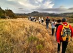
The first 2 miles on the West Horsethief Trail are mostly shaded and follow the creek.

image

View of Trabuco Canyon

After the first 2 miles you start to climb up the walls of Trabuco Canyon and the views begin to open up. This steep section is the toughest part of the hike. After 2 miles you reach the Main Divide Rd.

image

The Main Divide  Rd. offers some great views into Riverside County. Lake Elsinore is pictured above also visible from the road are San Jacinto and the San Bernardino Mountains. 

image

Los Pinos Ridge Trail

After 3 miles on the Rd you reach the Los Pinos Trail. This ridge line is one of my favorites in the range. The views from the ridge are amazing!

image

View from Los Pinos Peak

Once on the peak, enjoy the marvelous views an retrace your steps.  Go back to the main divide/los pinos junction and make a left to take the Trabuco Canyon trail. 

This shady downhill trail is my favorite!  It’s a bit rocky but the views are so worth it!

image

Trabuco Canyon Trail

image

This Trai will take you back to West Horsethief trail. Then return the way you came. This lollipop loop is one of the best in So Cal!

Trail route:
West Horsethief to Main Divide, Main Divide to Los Pinos Trail, Los Pinos  back down to Main Divide/Trabuco Canyon/ Los Pinos trail Junction,  Take Trabuco Canyon trail back to West Horsethief and back to parking lot.

● 13 mile Lollipop Loop
● 4th highest peak in the range.
● Beautiful views
● Dog friendly trail
● approx 2,500 ft of gain
● High clearance vehicle recommended

CLICK BELOW FOR GOOGLE MAPS LINK TO PARKING AREA
West Horsethief/Trabuco Canyon Trailhead

Follow me on Instagram for more outdoor photos and info on hikes.

Like this:

Like Loading...

Bear that killed hiker in West Milford, New Jersey | abc7.com

26 Wednesday Nov 2014

Posted by Alex G in News

≈ Leave a comment

Tags

bear, black bears, Hiking, nature, New Jersey, outdoors

image

This is a sad story and a great reminder not to run when you see a bear!

http://abc7.com/news/hiker-takes-pictures-of-bear-before-being-killed-by-bear/412640/

Like this:

Like Loading...

BRISTLECONE TRAIL – MT CHARLESTON

28 Wednesday May 2014

Posted by Alex G in Moderate Hikes, Outdoors

≈ Leave a comment

Tags

bristlecone trail., Hiking, Lee canyon, mountains, mt. Charleston, Nevada, outdoors

image

The Sisters and Lee Canyon

The Bristlecone Trail is located at the end of Lee Canyon in the Mt Charleston area of the Spring Mountains in Southern Nevada. The trail is around 5 miles long and can be done as a loop (with less than mile section of road.) Making it closer to 6 miles.

image

  There are 2 trailheads Upper Bristlecone and Lower Bristlecone. The lower trail takes you up an old road and is pretty much exposed for 3 miles until you get to the Bonanza Trail Junction.  Continue on the Bristlecone trail for the remaining 2 mile hike downhill to the Upper Bristlecone Trailhead.

image

Quaking Aspen

The hike can be done in any direction.  If you are starting early I would suggest doing it from the lower section first to get the exposed part out of the way.

image

image

Upper Bristlecone Trailhead

image

Quaking Aspen

Bristlecone pines, Ponderosa pines and Quaking Aspen can be found along the trail.

Click for Google maps to trailhead

Follow me on Instagram for more outdoor photos and trail info.

Like this:

Like Loading...

Link

Watch “Santiago Oaks Regional Park” on YouTube

01 Friday Nov 2013

Posted by octrailhikers in Uncategorized

≈ Leave a comment

Tags

Hiking, hiking trails, Santiago creek, Santiago oaks, villa park dam

Like this:

Like Loading...

Mt. Baldy- Ski Hut-Devils Backbone Loop

22 Tuesday Oct 2013

Posted by Alex G in Distance hikes, Outdoors, Peaks, Strenuous Hikes

≈ Leave a comment

Tags

Hiking, mount baldy, mountain, my baldy, nature, outdoors, peak

image

Mt Baldy is the highest mountain in the Los Angeles area and  is a very popular hike amongst the hiking community. I’ve had the pleasure of summiting this mountain 6 times and the view is just as breathtaking as the first time.

image

Ski Hut from the trail

The Ski Hut Trail begins about .6 miles up Falls Rd passing San Antonio Falls. There used to be a sign marking the obscure trail but that has since be removed. So keep by our eyes open as this trail is easy to miss. It is on the left hand side.

The Ski Hut marks the halfway point to the summit. This is a great place to stop have a snack and if you’re lucky you might even spot some wildlife.

image

Deer grazing just below the Ski Hut

From here you will cross the Baldy Bowl, do a little boulder scrambling and then back into the pine forest to continue the ascend to the summit. 

Once at the summit if you look in a Southeastern direction you will the the Devils Backbone Trail. Views from this trail are amazing!

image

Devils Backbone viewed fromnthe Summit

image

image

Take this trail down to the Baldy Notch (Ski lifts) from there you can either take the ski lifts down (if they’re running) or take the road down which is directly behind the restaurant. The road will take you back down and pass up the waterfall and leave you back at your car.

Click here for directions to the parking lot

***BE SURE TO USE EXTREME CAUTION WHEN HIKING ON THE DEVILS BACKBONE TRAIL. I DO NOT RECOMMEND HIKING THIS TRAIL AFTER SNOW FALL. PEOPLE HAVE DIED ON THIS TRAIL BEFORE ***

• 11.3 MILE LOOP
• HIKING POLES RECOMMENDED
• AMAZING VIEWS
• 3‚900 FT OF GAIN
• 7-9 HRS TO COMPLETE
• ADVENTURE PASS IS REQUIRED

Like this:

Like Loading...

Mile Mile and a Half Movie Screening

27 Tuesday Aug 2013

Posted by Alex G in Outdoors

≈ 1 Comment

Tags

backpacking, california, Hiking, JMT, John Muir trail, mountains, movie, nature, orange county, outdoors

image

http://www.tugg.com/events/5189

Mile…Mile & A Half in Orange, CA on Wednesday, September 25, 7:00pm

Trying to get enough people  signed up to get this awesome movie brought to OC for us to enjoy.

Please spread the word!

Like this:

Like Loading...

Gallery

Baker Canyon Night Hike with Google Glass

24 Monday Jun 2013

Posted by octrailhikers in Moderate Hikes

≈ Leave a comment

Tags

Android, Baker Canyon, blackstar canyon, Google Glass, Hiking, orange county, santiago canyon, ThroughGlass

This gallery contains 5 photos.

The “Super Moon” hike didn’t pan out the way I had hoped thanks to the clouds, but the hike was …

Continue reading →

The Wally Waldron Tree

31 Friday May 2013

Posted by Alex G in Distance hikes, Outdoors, Peaks, Strenuous Hikes

≈ Leave a comment

Tags

Hiking, limber pine, nature, outdoors, San Gabriel Mountains, wally Waldron

image

The Wally Waldron tree is  one of the oldest trees in the San Gabriel Mountains  estimated to be older than 1,500 years.
  It is named after Wally Waldron who was a member of the executive board of the LA area council of the Boy Scouts. 
  The tree is at the junction with the PCT and the trail that leads up to the summit of Mt. Baden Powell.

image

The Wally Waldron Tree viewed from the PCT

Like this:

Like Loading...

5 Hikers Lost in Eaton Canyon

05 Friday Apr 2013

Posted by octrailhikers in News

≈ 1 Comment

Tags

canyon, Eaton, hikers, Hiking, los angeles, lost, missing, mountains, San Gabriel, sheriffs, waterfall

image

Less than a month after a hiker lost their life in Eaton Canyon, a group of hikers has gone missing in the same area. The group set out at 8am Thursday morning and were expected back 8 hours later. The group was reported missing by one of the hikers’ parents Friday morning.

Eaton Canyon is located in the San Gabriel Mountains. The search for the missing hikers is being lead by the Los Angeles Sheriff’s Department. Eaton Canyon is an extremely popular hiking destination for Southern California natives, but has had more than of it’s faor share of rescues and deaths over the past few years.

Like this:

Like Loading...
← Older posts
Newer posts →

Blog Stats

  • 118,896 views

Top Posts & Pages

  • BLACK STAR CANYON INDIAN VILLAGE
  • HAGADOR CANYON
  • WATERFALLS OF TRABUCO CANYON
  • The Wally Waldron Tree
  • SAN MATEO PEAK
  • Quail Mounatin
  • ELEPHANT ROCK - VALLEY OF FIRE, NEVADA

Enter your email address to follow this blog and receive notifications of new posts by email.

Join 401 other subscribers

Advertisement

Archive

Create a free website or blog at WordPress.com.

Privacy & Cookies: This site uses cookies. By continuing to use this website, you agree to their use.
To find out more, including how to control cookies, see here: Cookie Policy
  • Follow Following
    • Your Favorite Hiker
    • Join 61 other followers
    • Already have a WordPress.com account? Log in now.
    • Your Favorite Hiker
    • Customize
    • Follow Following
    • Sign up
    • Log in
    • Report this content
    • View site in Reader
    • Manage subscriptions
    • Collapse this bar
%d bloggers like this: