• Easy Hikes
  • Moderate Hikes
  • Strenuous Hikes
  • Waterfalls
  • Outdoors
  • Distance hikes
  • Peaks
  • Caves
  • News
  • The 10 Essentials
  • Directions to our Favorite Trails

Your Favorite Hiker

~ Exploring SoCal and beyond!

Your Favorite Hiker

Category Archives: Moderate Hikes

Ladder Canyon (Mecca Hills, CA)

28 Monday Nov 2011

Posted by octrailhikers in Cave, Moderate Hikes, Outdoors

≈ 6 Comments

Tags

coachella valley, desert, Hiking, ladder canyon, ladders, mecca hills, painted canyon, palm springs, repelling, salton sea, san andreas fault, slot canyon

I would never have guessed that a desert hike would crack my top ten list, but the Ladder Canyon is by far the most visually stunning hike that I have personally experienced in Southern California.  I would definitely mark this as a must do for all hikers of all experience levels.

Big Ladder Canyon.

This trail is located in the the Mecca Hills of the Coachella Valley which border the northern shore of the Salton Sea. You probably would not want to attempt this hike during the Summer seeing how the temperature regularly surpasses 110 degrees during those months. We happened to catch a great break in the weather over the Thanksgiving weekend and the high temperature barely hit 80. This area is also known for very windy conditions and is also prone to flash flooding.

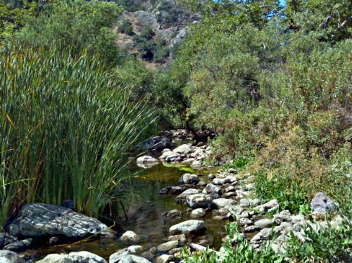
A portion of the Little Painted Canyon.

The four mile road into the trail, Painted Canyon Road, is unpaved and quite sandy. A 4-wheel drive vehicle is recommended but not necessary as long as you avoid the sandy patches of the road. We did see someone attempt to take their Mercedes coupe up the road for some unknown reason, and they wound up getting stuck in the sand. You should also pay close attention to where you park your vehicle. Try to select the more compacted soil to avoid getting stuck when trying to make your way out of the canyon.

The Ladder Canyon trail is a 4.5 to 5 mile loop, depending on the route you take, that actual begins and ends in the Big Painted Canyon. The slots of the Ladder Canyon are about 1/4 of a mile from the mouth of the Big Painted Canyon and are accessible only with the use of ladders that have been left by previous hikers. I have heard that the ladders can be swept away during flash floods. If we had not had the ladders present on the day of our hike I am confident in saying that the slots would be impassable.

One of the 3 ladders of the Ladder Canyon slots.

The slots only make up about 3/4 of a mile of this trail and then you make your way up 450 feet to the crest which supplies a beautiful view of the Salton Sea. From here you can choose to loop around through either the Little Painted Canyon, to the left, or the Big Painted Canyon, to the right. We came through the Big Painted Canyon and were treated with the opportunity to do a little repelling. The rock-scape in the canyon is not something I expected to ever find in the state of California. You can thank the San Andreas Fault for the spectacular scenery that is around every curve of the canyon.  Overall, this is a very family friendly hike. We observed kids of all ages making their way through the slots….not necessarily making it the entirety of the loop. This was a very awesome experience and I will definitely be out there again in the very near future.

One of the short ropes down the rock face.

The Salton Sea in the distance.

Like this:

Like Loading...

STURTEVANT FALLS / HERMIT FALLS

05 Wednesday Oct 2011

Posted by Alex G in Moderate Hikes, Outdoors, Strenuous Hikes, Waterfalls

≈ Leave a comment

Tags

Creek, Hiking, rock pools, waterfall

Sturtevant Falls is located in the San Gabriel Mountains and is accessible via the Chantry Flats Recreational Area. This is one of my favorite waterfalls for many reasons. One being that is is so easy to get to, this is a great hike for kids and adults. Another reason is the 50 ft waterfall that awaits you at the end of a 1.8 mile hike. Now you’re thinking 1.8 miles is not that bad…but there’s a catch.

The adventure begins in the parking lot which opens at 6am, and gets full really quick! Once you’ve found parking and displayed you’re Forest Adventure pass on you’re dashboard you are good to go.

Look for the sign that reads Sturtevant Falls and proceed past it to the trail that leads down into the canyon. Follow the fire road all the way down. Soon you will be hiking on a dirt trail with the sounds of the creek flowing in the background. The trail becomes very jungle like and before you know it you are walking along a cabin lined trail with the tree canopy providing shade on those warm summer months. There are a few tricky creek crossings along the way so be careful. If in doubt  just walk through the water…after all, its just water.

You will know when you are near, as the sounds of the gushing waterfall gets louder with every step. When you finally reach the waterfall you will be amazed at the size and how easy it was to reach it.

When I first did this hike earlier in the year i couldn’t believe how easy it was to reach such a natural wonder. I took some pictures and videos and had a snack enjoying the sights and sounds of Sturtevant Falls… Then I geared up and began to head out with the rest of the group. This is where the i realized that this easy hike was to good to be true. The hard part begins as soon you leave the dirt trail behind and pick up the fire road. This is about a 700 ft elevation gain in about .6 miles! On a cool day this isn’t too bad but on those hot summer days I recommend getting an early start.

After several breaks and many sips of water you will reach the halfway point back up to the parking lot. Here you will notice a trail marker that reads Hermit Falls 1.2 miles. Take this trail for an added adventure and the reward will be a beautiful hike with views of the San Gabriel Mountains and soon a up close and personal look at the creek. Hermit Falls consists of a few pools and multi tiered waterfalls. This destination is popular amongst teenagers who use this as a swimming hole, Jumping from the rocks above into the 15+ft deep pools and sliding down Natures Waterslide.

  • 700 ft elevation gain/loss
  • 50 ft waterfall
  • difficulty- Easy on the way in – moderate on way out
  • season- All year
  • Adventure Pass required
  • 3.6 miles roundtrip
  • bring plenty of water

Click here for directions

This slideshow requires JavaScript.

Like this:

Like Loading...

FISH CANYON WATERFALL

19 Friday Aug 2011

Posted by Alex G in Moderate Hikes, Outdoors, Waterfalls

≈ Leave a comment

Tags

Creek, fish canyon, Hiking, waterfall

Darlin' Donna waterall

Fish Canyon Falls is one of those sights that leaves you in awe. Truly one the best waterfalls that the San Gabriel Mountains has to offer. The adventure begins juat beyond the Parking Lot From here you begin your 2.2 mile adventure. Along the trail you will see ruins of old cabins,  wild berries, and posted signs with history of the canyon. With only 2 creek crossings this is one of the more easier and drier waterfall hikes around.

Once you’ve reached the waterfall getting to it can be a bit tough… between you and pool at the base lies a small but steep slope. With careful navigation make your way down and grab a seat.

This place gets bit crowded because on the weekends, so start your hike early for preferred seating. Trailhead opens at 7am. This is a well shaded trail along Fish Creek which is perfect for the hot months.

On your way back from the falls take the time to visit a hidden waterfall. I saw so many people walk right pass the trail and didn’t even realize it.  The trail is easy to find if you know what you are looking for. On your way back  look for the natural staircase that is formed from the roots of a tree. Shortly after passing that you will come across a bend in the trail with what appears to be a runoff  to your right.. follow that trail for 1 minute and there you will see Darlin’ Donna Waterfall, Fish Canyons Hidden beauty.

Enjoy !

Alex G

For directions click here

  • waterfall
  • creek
  • 4 miles r/t
  • free parking

Like this:

Like Loading...

WATERFALLS OF TRABUCO CANYON

17 Wednesday Aug 2011

Posted by Alex G in Moderate Hikes, Outdoors, Waterfalls

≈ 6 Comments

Tags

Creek, Hiking, trabuco, waterfall

Holy Jim Waterfall

Holy Jim Waterfall

Falls Canyon Waterfall

Falls Canyon Waterfall

Looking for a quick getaway? Have I got the spot for you. Located just a few minutes from both the city of Orange and Rancho Santa Margarita is a place called Trabuco Canyon . This natural wonderland is home to two of my favorite local waterfalls.

The first of the two is Holy Jim Waterfall which is around 4.25 miles round trip from the parking lot and back. (If you continue left on Holy Jim Rd, which is the road that’s directly behind the information board, you can drive about 3/4 of a mile further in and park at the Trailhead) This a short but rewarding hike. Lined with Oak, Sycamore, Maple and Fig Trees, this trail is very shady, great for hiking in the summer months. The trail begins after a slow and bumpy 4.5 mile drive up Trabuco Creek Rd which brings you to the Holy Jim Parking lot. From here go up the steps that lead to the trail and continue left. (Between here an the waterfall you will cross the creek about 6 times) You will soon find yourself walking along a trail lined with rustic cabins. When u reach the Holy Jim Trailhead follow this trail until you reach the Main Divide/ Holy Jim junction, continue right for a short distance until you reach the waterfall. Once here you can enjoy the sights and sounds of the 20ft wonder hidden in the canyon.

The 2nd and more impressive waterfall measuring at about 40ft is Falls Canyon Waterfall. This trail is a bit tricky to find because it is tucked away in a small canyon on the opposite side of the creek. To reach this trail one must start at the beginning of Trabuco Creek road and drive for approx 3.4 miles, (set your odometer). There is a small turnout on the right hand side that fits about 3 cars, park here, hike down to the creek and look for the smaller creek that feeds into Trabuco Creek. That is where the trail begins. After .4 miles you will reach Trabuco Canyons hidden gem!

I strongly recommended wearing pants and a long sleeve shirt for the falls canyon waterfall hike.

Here are the coordinates for Falls Canyon Waterfall 33.6790,-117.53446

  • high clearance vehicle required
  • waterfall
  • Creek
  • Poison oak
  • Adventure pass required
  • bug spray

    Posted with WordPress for BlackBerry.

Like this:

Like Loading...

San Juan Hill at Chino Hills State Park

16 Tuesday Aug 2011

Posted by Alex G in Moderate Hikes, Outdoors, Peaks

≈ 1 Comment

Tags

Chino Hills State Park, Hiking, San Juan Hill


Ever feel like hiking during the week? Well I did and I found the perfect place for a quiet hike with several trails and scenic views.

Chino Hills State Park offers 14,102 acres and 65 miles of trails. But one trail stands out from the rest and that would be South Ridge Trail to San Juan Hill.

We accessed the park via the Rimcrest and Blue Gum entrance in Yorba Linda. From the trail head we headed east on the South Ridge Trail for 2.8 miles. On our hike we saw a lot of  Buffalo Gourd, Milk Thistle and the occasional Biker. Other than that, the park was all ours.
Although short, this trail is not easy, there is a 1000 ft elevation gain in 2.8 miles. There are no trees along the trail so hiking here in the summer months could get very hot, very quick (bring enough water). Once you’ve reached and conquered all .1 miles of the San Juan Hill Trail you are greeted with a wonderful view of Orange County.
Enjoy!

-Alex G

Posted with WordPress for BlackBerry.

Like this:

Like Loading...

SWITZER FALLS

16 Tuesday Aug 2011

Posted by Alex G in Moderate Hikes, Outdoors, Strenuous Hikes, Waterfalls

≈ Leave a comment

Tags

creek crossings, Hiking, mountains, waterfall

A few months ago our love for nature led us to this wonderful place called Switzer Falls.  The trail begins in the parking lot of the Switzer Falls picnic area, after crossing a small bridge we continued hiking along the oak lined trail. A few creek crossings and a mile later we reached the switchbacks that lead up the canyon wall, at this point we left the creek and continued up the canyon about 700ft. With beautiful views of  Bear Canyon and a glimpse of Switzer Falls down below, the elevation gain was worth the struggle. We reached the Gabrielino/Bear Canyon junction and proceeded to our left and continued on the Switzer Falls Trail for anther 1.4 miles. Once at the bottom of the canyon we met up with the creek once again. We continued up creek for a few minutes until we reached the Lower Falls. At a bout 25 ft this waterfall is well worth the hike. For the more adventurous hiker one can follow the narrow trail to the right to reach Upper Switzer Falls, which is a beauty! At 50ft with a shallow pool at the base this is a great place to cool off and enjoy nature at its best.  This is definitely a must do hike  for anyone who enjoys the great outdoors.

  • 5 miles R/T
  • 700 ft elevation gain
  • 2 waterfalls
  • creek crossings
  • Like this:

    Like Loading...

Malibu Creek Hike (M*A*S*H Site)

15 Monday Aug 2011

Posted by octrailhikers in Moderate Hikes, Outdoors

≈ Leave a comment

Tags

Creek, Hiking, Lake, Malibu, Parks, Rock Climbing, Trails

image

image

image

image

     We ventured away from Orange County this weekend and headed for the cooler weather of Malibu Creek State Park. As it turned out, it ended up being quite warm in Malibu on this particular day.
      This is a state park so there is a $12 fee to use the parking lot. Most people, including us, were parking on the road just outside of the park to avoid the fee.
     I would definitely categorize this as a family friendly park. You have several trails to choose from and all of them have minimal elevation gain. The trails are wide and well maintained for the most part, and there are several port ‘o potties around that, according to their service logs, are cleaned pretty regularly.
     The Rock Pool trail is roughly 3.5 miles roundtrip  with an elevation gain of 150 feet. The payoff is a beautiful rock pool and picnic area. Being that it is pretty easy to get to, the rock pool is usually swarming with families. It was a bit disheartening to see the large amounts of trash and discarded clothing strewn about. If I were to visit the rock pool again I would definitely try to be the first person there in the morning.
     The Century Lake trail is 4.5 miles roundtrip with an elevation gain of 200 feet. I wouldn’t really call this a lake. It is closer to a pond complete with lilypads. The water here is due to a dam. I witnessed a couple of young kids swimming out in the water. I wouldn’t recommend swimming here though.
     My favorite trail of the day was definitely the M*A*S*H Site trail. This trail ends up being 6.5 miles roundtrip with an elevation gain of 300 feet. When you reach the M*A*S*H Site you will find a couple of rusted out vehicles as well as a few posts with information about the television show filming that took place in the area. I was pleasantly surprised at how few people actually made it out to this area of the park.
     We began our hike at 8 a.m. and there weren’t too many people around, but on our way back out it was really starting to get packed. Get there early to avoid the crowds and you’ll also have a chance to see the deer that travel the creek bed in the early morning hours.

-FPMiv

Posted from WordPress for Android

Like this:

Like Loading...
Newer posts →

Blog Stats

  • 119,145 views

Top Posts & Pages

  • BLACK STAR CANYON TO SILVERADO CANYON

Enter your email address to follow this blog and receive notifications of new posts by email.

Join 401 other subscribers

Advertisement

Archive

Create a free website or blog at WordPress.com.

Privacy & Cookies: This site uses cookies. By continuing to use this website, you agree to their use.
To find out more, including how to control cookies, see here: Cookie Policy
  • Follow Following
    • Your Favorite Hiker
    • Join 61 other followers
    • Already have a WordPress.com account? Log in now.
    • Your Favorite Hiker
    • Customize
    • Follow Following
    • Sign up
    • Log in
    • Report this content
    • View site in Reader
    • Manage subscriptions
    • Collapse this bar
 

Loading Comments...
 

    %d bloggers like this: